
 |
 |
 |
 |
 |
 |
 |
 |
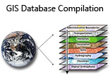
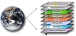
GIS database compilations allow for the scientific integration of information that enables an organisation to make sound financial and technical business decisions around a project of interest.
Primarily, data is acquired using a variety of techniques:
- Acquisition of public and private domain data
- GIS Data-Capture
- GIS Analysis and Manipulation
- Spatial Modeling-DEM, hydrology and surface interpolation
Secondly, data from different key related disciplines that relate to a core discipline should ideally be viewed in totality rather than independently utilizing an accurate visually enabled platform.
Core Geology and Mining
Property and Hydrology Assessment
Agriculture and Tourism (Olive Route)
Related
Geophysics
Surveyor General
Local Tourism Authority
Related
Geochemistry
Municipal Water Supplier
Growers Association
Related
Topography
Local and Regional Municipality
Department of Transport
Related
Remote Sensing
Residents Association
Demarcation Board
Related
Environmental
Environmental
Environmental
| Website updated 2026 I Copyright 2026 Gisnet cc I All rights reserved |
| Website designed by KLA Consulting cc I www.klaconsulting.co.za |